Huoyanshan and Longteng Bridge: Hiking Risks and Itinerary Choices
Visiting Huoyanshan's natural terrain is fundamentally different from seeing the Longteng Bridge ruins, so do not plan both as quick roadside stops.
Location
Sanyi Township, Miaoli County
Topic
Huoyanshan hiking
Navigation
Confirm destination
Before visiting
Check current notices
Assess the hike
Check trail closures, forecast, equipment and fitness before hiking, particularly in heat or after rain.
Prioritize one main activity
If hiking is the focus, visit the bridge briefly before or afterward. Families and older travelers should avoid squeezing a full hike into a packed day.
Respect restricted areas
Stay on authorized routes and follow site instructions.
Combining Huoyanshan and Longteng Bridge
Huoyanshan is a terrain and hiking destination; Longteng Bridge is a historic railway monument. They should not be treated as two equivalent quick sightseeing stops.
Checks before the hike
Review trail restrictions, weather, equipment and your group’s fitness. Hot days and wet ground call for extra caution.
Choosing an itinerary
If the mountain hike is your priority, use Longteng Bridge as a shorter stop before or after. Families with young children and older adults should avoid forcing a full hike into a tightly scheduled day.
Frequently asked questions
What if I only want to see the landforms? Look for a legal viewing point; do not treat unverified paths as shortcuts.
Does Longteng Bridge require a ticket? Outdoor viewing and the ticketed rail bike are separate activities.
Where should I navigate? This guide’s destination is Huoyanshan. Use its dedicated map search and verify the result’s name and county before setting out, since no fixed Google Place ID has been established here. If you also visit Longteng Bridge, set it as a separate stop.
Related information
- Transportation to Longteng Bridge
- Parking
- Rail bike route options
- Nearby attractions
- Operator announcements
Huoyanshan’s distinctive landforms
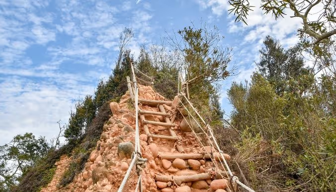
Huoyanshan is known for reddish-brown conglomerate cliffs and erosion features. These differ fundamentally from Longteng Bridge’s red brick: one is a natural landform, the other an engineered railway structure.
Hiking versus a short stop
For an official mountain trail, check its length, elevation gain, weather and access restrictions. Bring appropriate footwear, water and sun protection. Parts of the nature reserve have entry rules; valleys visible in photographs are not automatically open to visitors.
Photographing the landscape safely
Use a telephoto lens from a safe, permitted trail viewpoint to capture the red cliffs. Avoid unstable slopes, rockfall zones and loose ground after rain. Never approach a collapse edge just for a photograph.
Real-world trail reference: James Discover outdoor report.
Explore the location from different angles
Plan your visit with Google Maps
Remains of Longteng Bridge (龍騰斷橋/魚藤坪斷橋)
Huoyanshan Sanyi Miaoli Taiwan
For official tourism information see Taiwan Tourism Administration (official tourism portal) . Map pins, reviews and business information change over time; follow road signs and on-site guidance for parking and walking routes.
Read next
- Seasons and climate Longteng Bridge Through the Seasons: Weather, Stream Conditions and Wildlife An overview of twelve months of typical temperatures, rain, humidity, creek conditions, wildlife and what to wear along the Old Mountain Line.
- Visitor services Longteng Bridge Visitor Facilities: Toilets, Parking, Food and Supplies Plan for toilets, parking, food, stays, convenience stores, fuel, EV charging, medical help, mobile reception and accessible family facilities along the Old Mountain Line.
- Science and responsibility Why Did Longteng Bridge Break? Earthquake Engineering and Visitor Responsibility Understand how brick arches failed in the 1935 earthquake and why protecting the remains and their wildlife habitats matters.